Ammuriya, Nablus
| 'Ammuriya | |
|---|---|
| Other transcription(s) | |
| • Arabic | ﺔﻴﻭﺭﻤﻋ |
| • Also spelled |
'Amuria (official) 'Amuriya (unofficial) |
  'Ammuriya Location of 'Ammuriya within the Palestinian territories | |
| Coordinates: 32°4′1″N 35°12′53″E / 32.06694°N 35.21472°ECoordinates: 32°4′1″N 35°12′53″E / 32.06694°N 35.21472°E | |
| Palestine grid | 169/163 |
| Governorate | Nablus |
| Government | |
| • Type | Local Development Committee |
| • Head of Municipality | Sulaiman Hakawati[1] |
| Population (2007) | |
| • Jurisdiction | 302 |
'Ammuriya (Arabic: ﺔﻴﻭﺭﻤﻋ, also spelled 'Amuria)[2] is a Palestinian village in the Nablus Governorate in the northern West Bank, located south of Nablus. Nearby localities include Iskaka to the north, al-Lubban ash-Sharqiya to the east, Abwein to the south, 'Arura and Mazari an-Nubani to the southwest and Salfit to the northwest. According to the Palestinian Central Bureau of Statistics (PCBS) census, 'Ammuriya had a population of 302 in 2007. There were 48 households and five business establishments in the village.[3]
History
Pottery sherds from Iron Age II, Hellenistic/Roman, Crusader/Ayyubid and Mamluk eras have been found here.[4]
Ottoman era
In 1596, it appeared in Ottoman tax registers as "′Ammuriya", a village in the nahiya of Jabal Qubal in the liwa of Nablus. It had a population of 7 households and 1 bachelor, all Muslim. The villagers paid taxes on wheat, barley, summer crops, olive trees, goats and beehives, and a press for olive oils or grapes; a total of 0,000 akçe.[5]
In 1882, the Palestine Exploration Fund's Survey of Western Palestine described it as "A small village on high ground".[6]
British Mandate era
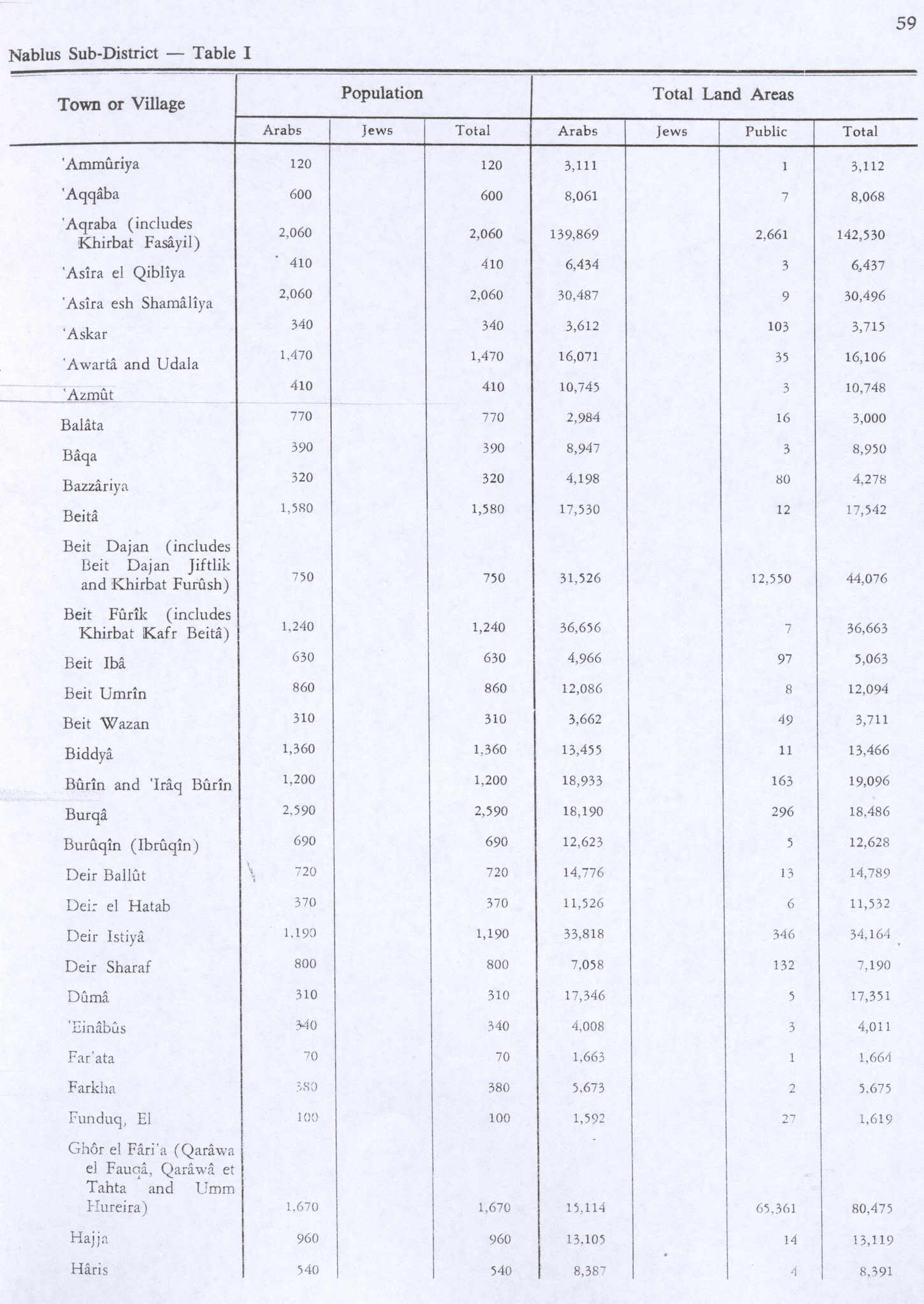
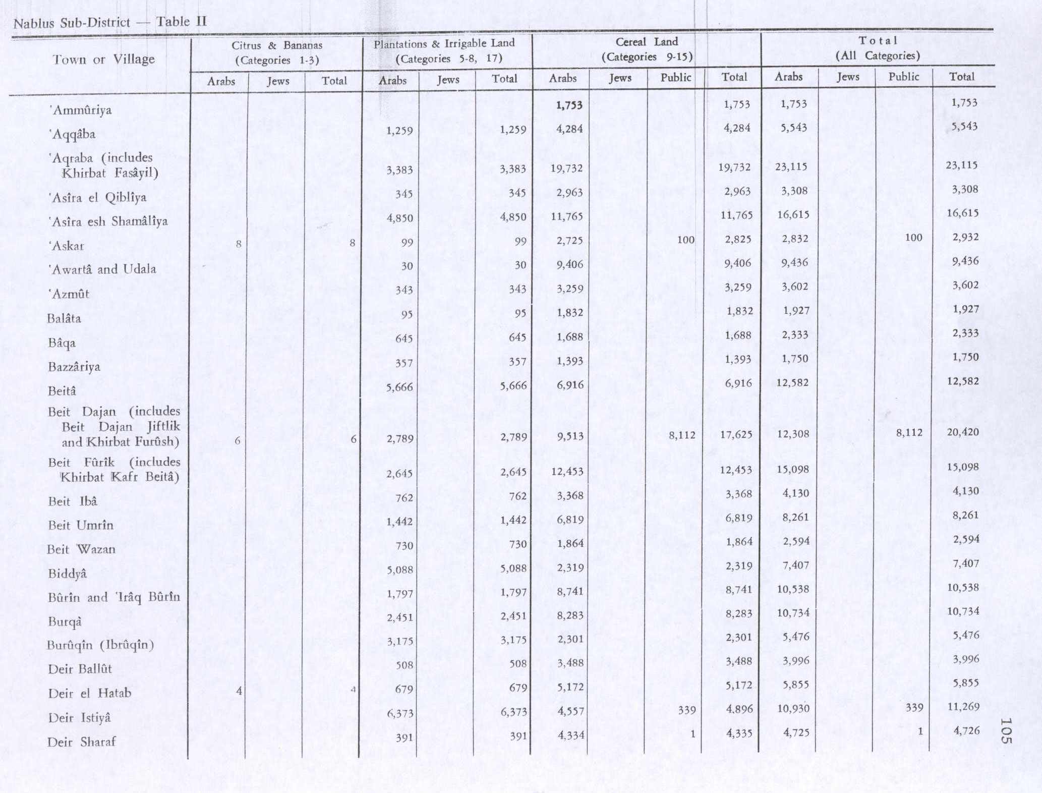
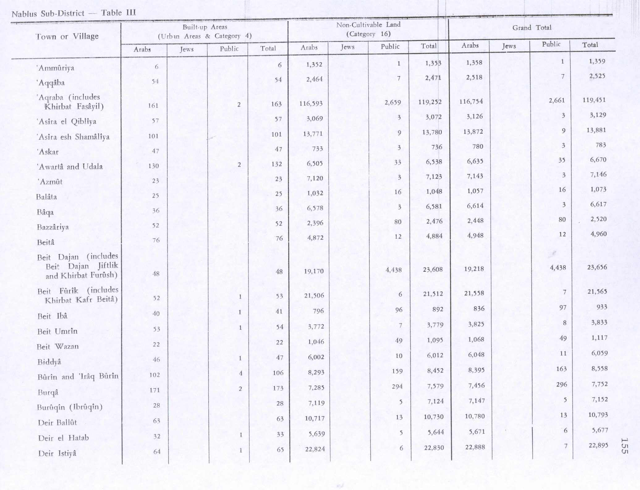
In the 1922 census of Palestine, conducted by the British Mandate authorities, the population was 69, all Muslim,[1][7] while at the time of the 1931 census, Ammuriya had 19 occupied houses and a population of 85, all Muslim.[8] In 1945 the population was 120, all Muslims,[9] with 3111 dunams of land, according to an official land and population survey.[10] Of this, 1753 dunams were used for cereals,[11] while 6 dunams were built-up land.[12]
Israel (post-1967)
In 1967 the village came under Israeli occupation after the Six-Day War, and the same year the population was found to be 130.[13]
References
- 1 2 Ammuriya Profile. Jerusalem Media and Communications Center (JMCC). 2007-02-09.
- ↑ From Amorites, according to Palmer, 1881, p. 225
- ↑ 2007 PCBS Census. Palestinian Central Bureau of Statistics. p. 110.
- ↑ Finkelstein and Lederman, 1997, p. 484
- ↑ Hütteroth and Abdulfattah, 1977, p. 136.
- ↑ Conder and Kitchener, 1882, SWP II, p. 283
- ↑ Barron, 1923, Table IX, Sub-district of Nablus, p. 25
- ↑ Mills, 1932, p. 59
- ↑ Department of Statistics, 1945, p. 18
- ↑ Government of Palestine, Department of Statistics. Village Statistics, April, 1945. Quoted in Hadawi, 1970, p. 59
- ↑ Government of Palestine, Department of Statistics. Village Statistics, April, 1945. Quoted in Hadawi, 1970, p. 105
- ↑ Government of Palestine, Department of Statistics. Village Statistics, April, 1945. Quoted in Hadawi, 1970, p. 155
- ↑ Perlmann, Joel (November 2011 – February 2012). "The 1967 Census of the West Bank and Gaza Strip: A Digitized Version" (PDF). Levy Economics Institute. Retrieved 24 June 2016.

Bibliography
 |
Wikimedia Commons has media related to Ammuriya, Nablus. |
- Barron, J. B., ed. (1923). Palestine: Report and General Abstracts of the Census of 1922. Government of Palestine.
- Conder, Claude Reignier; Kitchener, H. H. (1882). The Survey of Western Palestine: Memoirs of the Topography, Orography, Hydrography, and Archaeology. 2. London: Committee of the Palestine Exploration Fund.
- Department of Statistics (1945). Village Statistics, April, 1945. Government of Palestine.
- Finkelstein, Israel; Lederman, Zvi, eds. (1997). Highlands of many cultures. Tel Aviv: Institute of Archaeology of Tel Aviv University Publications Section. ISBN 965-440-007-3.
- Hadawi, Sami (1970). Village Statistics of 1945: A Classification of Land and Area ownership in Palestine. Palestine Liberation Organization Research Center.
- Hütteroth, Wolf-Dieter; Abdulfattah, Kamal (1977). Historical Geography of Palestine, Transjordan and Southern Syria in the Late 16th Century. Erlanger Geographische Arbeiten, Sonderband 5. Erlangen, Germany: Vorstand der Fränkischen Geographischen Gesellschaft. ISBN 3-920405-41-2.
- Mills, E., ed. (1932). Census of Palestine 1931. Population of Villages, Towns and Administrative Areas. Jerusalem: Government of Palestine.
- Palmer, E. H. (1881). The Survey of Western Palestine: Arabic and English Name Lists Collected During the Survey by Lieutenants Conder and Kitchener, R. E. Transliterated and Explained by E.H. Palmer. Committee of the Palestine Exploration Fund.
- Perlmann, Joel: The 1967 Census of the West Bank and Gaza Strip: A Digitized Version. Annandale-on-Hudson, N.Y.: Levy Economics Institute of Bard College. November 2011 – February 2012. [Digitized from: Israel Central Bureau of Statistics, Census of Population and Housing, 1967 Conducted in the Areas Administered by the IDF, Vols. 1–5 (1967–70), and Census of Population and Housing: East Jerusalem, Parts 1 and 2 (1968–70).]
External links
- Welcome To 'Ammuriya
- Survey of Western Palestine, Map 14: IAA, Wikimedia commons

| Cities |
|   |
|---|---|---|
| Municipalities | ||
| Villages |
| |
| Refugee camps | ||