Jarash, Jerusalem
| Jarash | |
|---|---|
  Jarash | |
| Arabic | جرش |
| Name meaning | Jerash; personal name[1] |
| Subdistrict | Jerusalem |
| Coordinates | 31°43′47.29″N 35°00′57.66″E / 31.7298028°N 35.0160167°ECoordinates: 31°43′47.29″N 35°00′57.66″E / 31.7298028°N 35.0160167°E |
| Palestine grid | 151/126 |
| Population | 190[2] (1945) |
| Area | 3,518[2] dunams |
| Date of depopulation | 21,October, 1948[3] |
| Cause(s) of depopulation | Military assault by Yishuv forces |
Jarash (Arabic: جرش) was a Palestinian village that was depopulated over the course of 1948 Arab-Israeli war. Located 25 kilometers west of Jerusalem, Jarash was a wholly Arab village of 220 inhabitants in 1948.
History
To the east of the village lay Khirbat Sira, which is identified with a Mamluk/Ottoman village.[4] In 1863 Victor Guérin found Jarash to have 25 inhabitants.[5]
In 1883, the Palestine Exploration Fund's Survey of Western Palestine described Jarash was described as a village built on the spur of a hill with olive trees growing below it.[6]
British Mandate era
In the 1922 census of Palestine, conducted by the British Mandate authorities, Jarash had a population 115, all Muslims,[7] increasing in the 1931 census to 164, still all Muslim, in a total of 33 houses.[8]
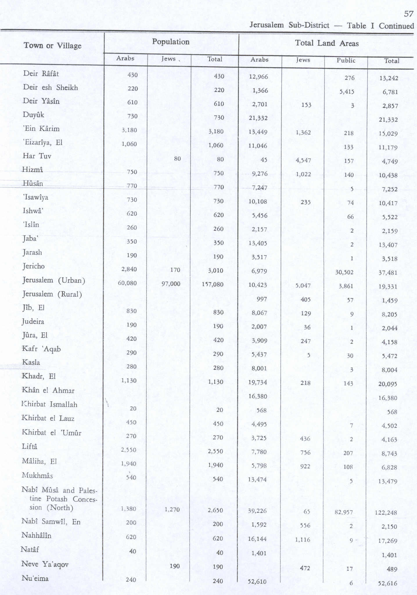
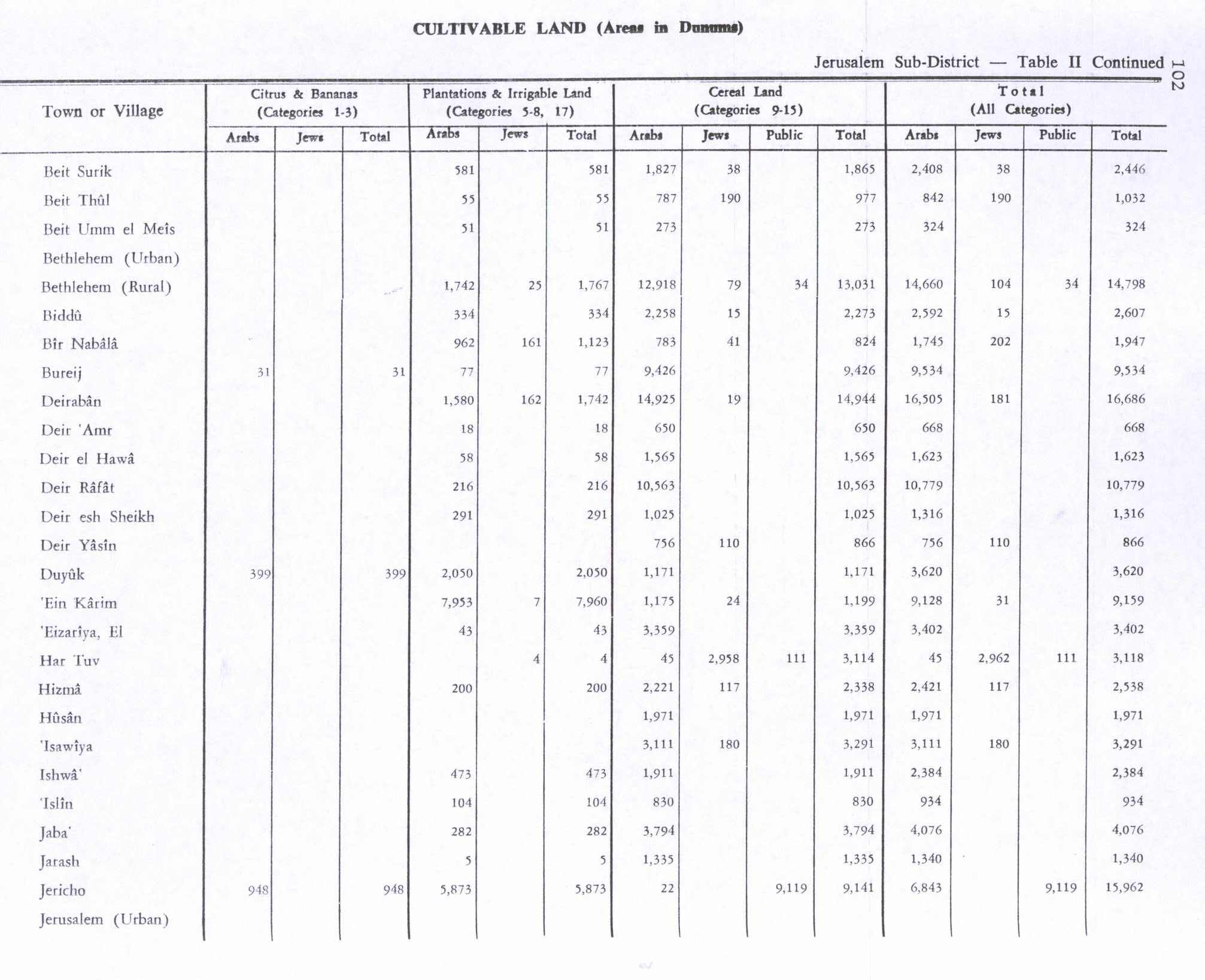
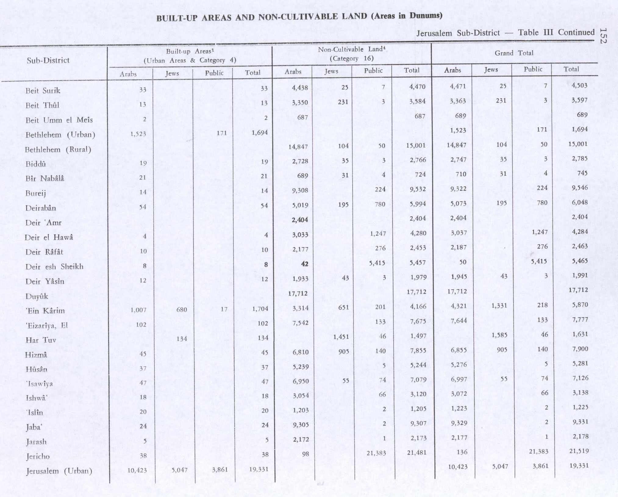
In 1945 the population was 190, all Arabs, while the total land area was 3,518 dunams, according to an official land and population survey.[2] Of this, 5 were allocated for plantations and irrigable land, 1,335 for cereals,[9] while 5 dunams were classified as built-up areas.[10]
1948 and aftermath
There are no Israeli settlements on the site of the former town, though it is located within present-day Israel.
Walid Khalidi writes of Jarash:
"The site is overgrown with grass, interspersed with the debris of destroyed houses and stones from the terraces. The ruins of a cemetery lie northwest of the site. Groves of trees cover two hills to the west of the site that are separated by a valley. Carob, fig, almond, and olive trees grow on these hills."[11]
See also
- List of Arab towns and villages depopulated during the 1948 Arab-Israeli War
- List of villages depopulated during the Arab-Israeli conflict
References
- ↑ Palmer, 1881, p. 296
- 1 2 3 Government of Palestine, Department of Statistics. Village Statistics, April, 1945. Quoted in Hadawi, 1970, p. 57
- ↑ Morris, 2004, p. xx, village #341. Also gives the cause for depopulation
- ↑ Hütteroth and Abdulfattah, 1977, p. 154
- ↑ Guérin, 1869, p. 322
- ↑ Conder and Kitchener, 1883, III:25. Quoted in Khalidi, 1992, p. 296
- ↑ Barron, 1923, Table V, Sub-district of Hebron, p. 10
- ↑ Mills, 1932, p. 20
- ↑ Government of Palestine, Department of Statistics. Village Statistics, April, 1945. Quoted in Hadawi, 1970, p. 102
- ↑ Government of Palestine, Department of Statistics. Village Statistics, April, 1945. Quoted in Hadawi, 1970, p. 152
- ↑ Khalidi, 1992, p. 297
Bibliography
- Barron, J. B., ed. (1923). Palestine: Report and General Abstracts of the Census of 1922. Government of Palestine.
- Conder, Claude Reignier; Kitchener, H. H. (1883). The Survey of Western Palestine: Memoirs of the Topography, Orography, Hydrography, and Archaeology. 3. London: Committee of the Palestine Exploration Fund.
- Guérin, Victor (1869). Description Géographique Historique et Archéologique de la Palestine (in French). 1: Judee, pt. 3. Paris: L'Imprimerie Nationale.
- Hadawi, Sami (1970). Village Statistics of 1945: A Classification of Land and Area ownership in Palestine. Palestine Liberation Organization Research Center.
- Hütteroth, Wolf-Dieter; Abdulfattah, Kamal (1977). Historical Geography of Palestine, Transjordan and Southern Syria in the Late 16th Century. Erlanger Geographische Arbeiten, Sonderband 5. Erlangen, Germany: Vorstand der Fränkischen Geographischen Gesellschaft. ISBN 3-920405-41-2.
- Khalidi, Walid (1992). All That Remains: The Palestinian Villages Occupied and Depopulated by Israel in 1948. Washington D.C.: Institute for Palestine Studies. ISBN 0-88728-224-5.
- Mills, E., ed. (1932). Census of Palestine 1931. Population of Villages, Towns and Administrative Areas. Jerusalem: Government of Palestine.
- Morris, Benny (2004). The Birth of the Palestinian Refugee Problem Revisited. Cambridge University Press. ISBN 978-0-521-00967-6.
- Palmer, E. H. (1881). The Survey of Western Palestine: Arabic and English Name Lists Collected During the Survey by Lieutenants Conder and Kitchener, R. E. Transliterated and Explained by E.H. Palmer. Committee of the Palestine Exploration Fund.
External links
- Welcome To Jarash
- Survey of Western Palestine, Map 17: IAA, Wikimedia commons
- Jarash from the Khalil Sakakini Cultural Center