Ein Qiniya
| Ein Qiniya | |
|---|---|
| Other transcription(s) | |
| • Arabic | عين قينيا |
| • Also spelled |
Ayn Kiniya (official) Ein Qinya (unofficial) |
  Ein Qiniya Location of Ein Qiniya within the Palestinian territories | |
| Coordinates: 31°55′37″N 35°08′56″E / 31.927°N 35.149°ECoordinates: 31°55′37″N 35°08′56″E / 31.927°N 35.149°E | |
| Palestine grid | 164/148 |
| Governorate | Ramallah & al-Bireh |
| Government | |
| • Type | Local Development Committee |
| Population (2006) | |
| • Jurisdiction | 817 |
| Name meaning | The crimson spring[1] |
Ein Qiniya or 'Ayn Kiniya (Arabic: عين قينيا) is a Palestinian village in the northern West Bank, located 7 kilometers (4.3 mi) northwest of Ramallah and is a part of the Ramallah and al-Bireh Governorate. Ein Qiniya has existed since the Roman-era of rule in Palestine.[2] The village is very small with no public structures or institutions and is governed by a local development committee. Ein Qiniya is regionally notable for being a spring and autumn time picnic resort.[2]
There is an annual walk on March 4 from Ramallah to Ein Qiniyya in celebration of the spring.[3]
History
A Middle Bronze Age tomb was discovered here in 1934.[4] Potsherds from the Hellenistic and Umayyad/Abbasid period have been found.[4]
Ein Qiniya has traditionally been identified with Ainqune of the Crusader era, one of the fiefs given by King Godfrey to the Church of the Holy Sepulchre.[5][6] However, Finkelstein writes that this identification should be reconsidered.[7] Potsherds from the Mamluk era have also been found here.[4]
Ottoman era
In 1517, the village was included in the Ottoman empire with the rest of Palestine, and in the 1596 tax-records it appeared as Ayn Qinya, located in the Nahiya of Jabal Quds of the Liwa of Al-Quds. The population was 32 households, all Muslim. They paid a tax rate of 33,3% on agricultural products, which included wheat, barley, summer crops, olive trees, vineyards and fruit trees, occasional revenues, goats and beehives; a total of 4760 Akçe.[8][9]
In 1882, the Palestine Exploration Fund's Survey of Western Palestine (SWP) described Ain Kanieh as "a village of moderate size on a ridge".[10]
British Mandate era

In 1917, most of the village's inhabitants were evacuated by British Mandate troops for suspicion that residents killed a British officer and relocated to Beitunia and Yalo.[2] In the 1922 census of Palestine, conducted by the British Mandate authorities, 'Ain Qinia had a population of 56, all Muslims.[11] This had increased in the 1931 census to 83, still all Muslims, in a total of 26 houses.[12]
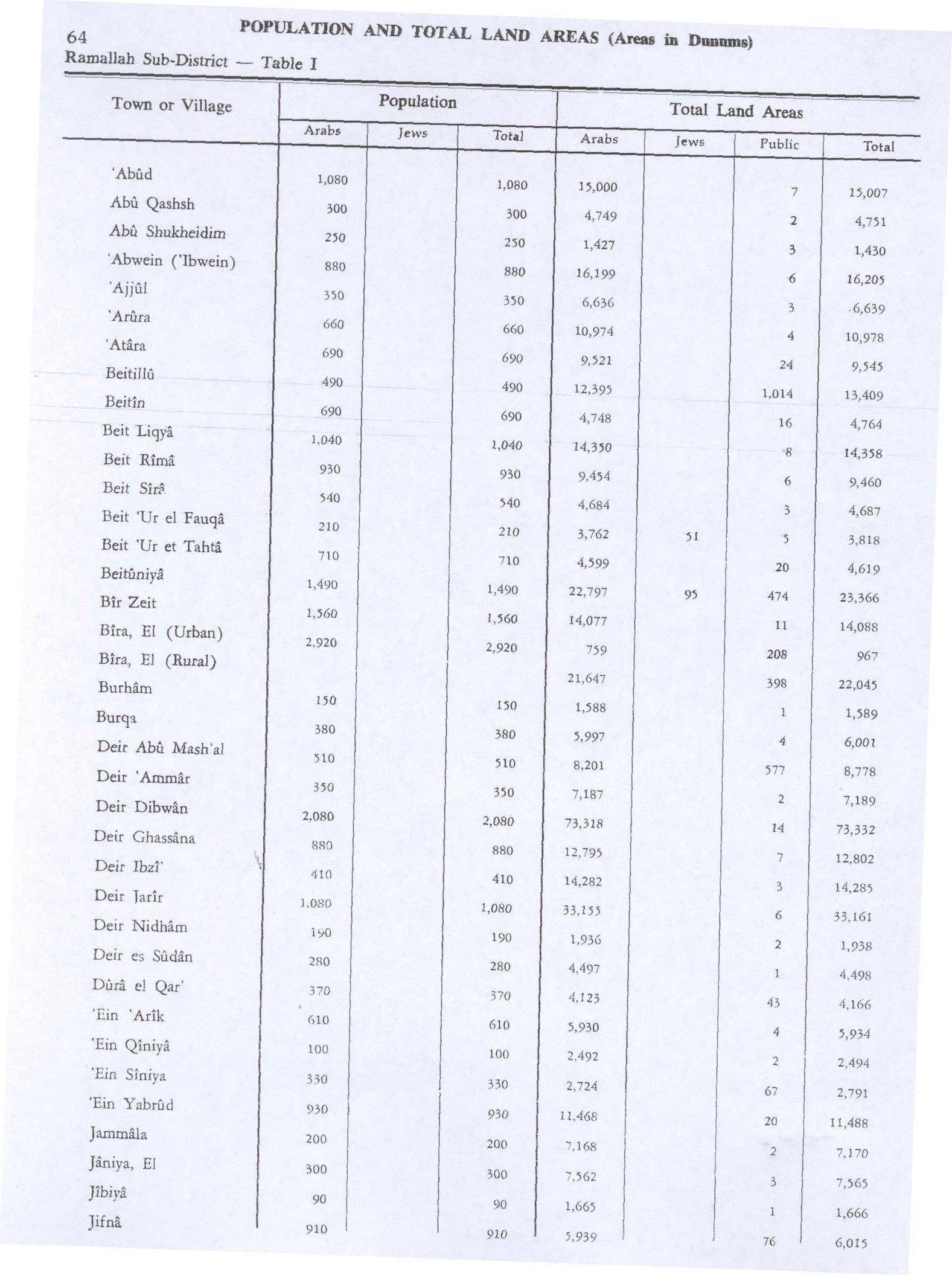
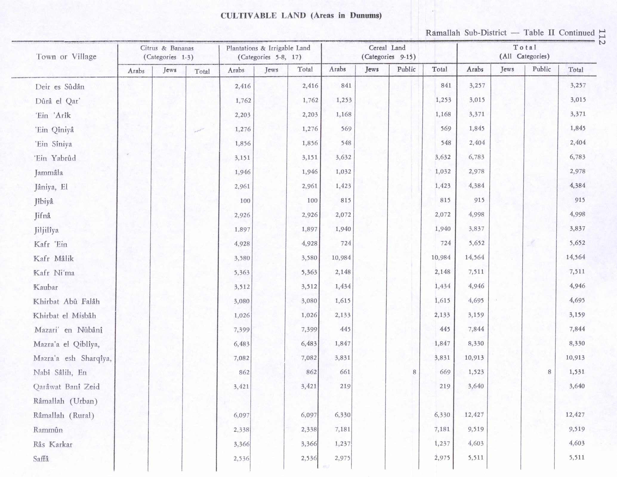
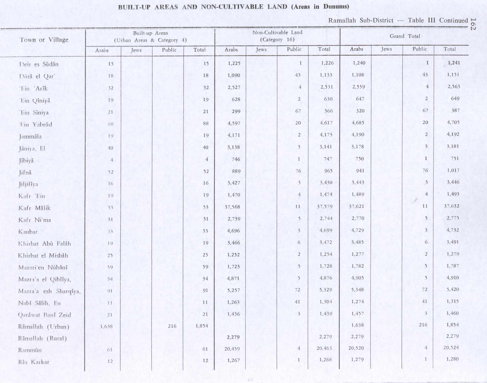
In 1945 the population was 100, all Muslims,[13] while the total land area was 2,494 dunams, according to an official land and population survey.[14] Of this, 1,276 were allocated for plantations and irrigable land, 569 for cereals,[15] while 19 dunams were classified as built-up areas.[16]
1948-1967
In the wake of the 1948 Arab–Israeli War, and after the 1949 Armistice Agreements, Ein Qiniya came under Jordanian rule.
1967 and after
After the Six-Day War in 1967 Ein Qiniya has been under Israeli occupation.
In 1982 residents numbered 101, then after a mass migration of other Palestinians to the Ein Qiniya, the population rose to 464 in 1984.[17] According to the Palestinian Central Bureau of Statistics, in 2006 it had a population of 807.[18] In the 2007 PCBS census, there were 817 people living in the village.[19]
References
- ↑ Palmer, 1881, p. 222
- 1 2 3 Ein Qinya (The Spring of Qinya) - Ramallah Jerusalem Media and Communications Centre.
- ↑ Events Calendar Jerusalem Post.
- 1 2 3 Finkelstein et al., 1997, p. 337
- ↑ de Roziére, 1849, p. 100
- ↑ Conder and Kitchener, 1883, SWP III, p. 11
- ↑ Röhricht, 1887, p. 204; Röhricht, 1893, RRH, p. 50, No 200; both cited by Finkelstein et al., 1997, p. 337
- ↑ Hütteroth and Abdulfattah, 1977, p. 118
- ↑ Toledano, 1984, p. 289, has 'Ain Qinya located at 35°08′35″E 31°55′35″N
- ↑ Conder and Kitchener, 1882, SWP II, p. 295
- ↑ Barron, 1923, Table VII, Sub-district of Ramallah, p. 16
- ↑ Mills, 1932, p. 49
- ↑ Department of Statistics, 1945, p. 26
- ↑ Government of Palestine, Department of Statistics. Village Statistics, April, 1945. Quoted in Hadawi, 1970, p. 64
- ↑ Government of Palestine, Department of Statistics. Village Statistics, April, 1945. Quoted in Hadawi, 1970, p. 112
- ↑ Government of Palestine, Department of Statistics. Village Statistics, April, 1945. Quoted in Hadawi, 1970, p. 162
- ↑ Welcome to 'Ayn Kiniya
- ↑ Projected Mid -Year Population for Ramallah & Al Bireh Governorate by Locality 2004- 2006 Palestinian Central Bureau of Statistics.
- ↑ 2007 PCBS Census. Palestinian Central Bureau of Statistics. p.114.

Bibliography
 |
Wikimedia Commons has media related to Ein Qiniya. |
- Barron, J. B., ed. (1923). Palestine: Report and General Abstracts of the Census of 1922. Government of Palestine.
- Conder, Claude Reignier; Kitchener, H. H. (1882). The Survey of Western Palestine: Memoirs of the Topography, Orography, Hydrography, and Archaeology. 2. London: Committee of the Palestine Exploration Fund.
- Conder, Claude Reignier; Kitchener, H. H. (1883). The Survey of Western Palestine: Memoirs of the Topography, Orography, Hydrography, and Archaeology. 3. London: Committee of the Palestine Exploration Fund.
- Department of Statistics (1945). Village Statistics, April, 1945. Government of Palestine.
- Finkelstein, Israel; Lederman, Zvi, eds. (1997). Highlands of many cultures. Tel Aviv: Institute of Archaeology of Tel Aviv University Publications Section. ISBN 965-440-007-3.
- Hadawi, Sami (1970). Village Statistics of 1945: A Classification of Land and Area ownership in Palestine. Palestine Liberation Organization Research Center.
- Hütteroth, Wolf-Dieter; Abdulfattah, Kamal (1977). Historical Geography of Palestine, Transjordan and Southern Syria in the Late 16th Century. Erlanger Geographische Arbeiten, Sonderband 5. Erlangen, Germany: Vorstand der Fränkischen Geographischen Gesellschaft. ISBN 3-920405-41-2.
- Mills, E., ed. (1932). Census of Palestine 1931. Population of Villages, Towns and Administrative Areas (PDF). Jerusalem: Government of Palestine.
- Palmer, E. H. (1881). The Survey of Western Palestine: Arabic and English Name Lists Collected During the Survey by Lieutenants Conder and Kitchener, R. E. Transliterated and Explained by E.H. Palmer. Committee of the Palestine Exploration Fund.
- de Roziére, ed. (1849). Cartulaire de l'église du Saint Sépulchre de Jérusalem: publié d'après les manuscrits du Vatican (in Latin and French). Paris: Imprimerie nationale.
- Röhricht, R. (1887). "Studien zur mittelalterlichen Geographie und Topographie Syriens". Zeitschrift des Deutschen Palästina-Vereins. 10: 195–344.
- Röhricht, Reinhold (1893). (RRH) Regesta regni Hierosolymitani (MXCVII-MCCXCI) (in Latin). Berlin: Libraria Academica Wageriana. (Röhricht, 1893, RRH, pp. 16-17, No 74)
- Toledano, E. (1984). "The Sanjaq of Jerusalem in the Sixteenth Century: Aspects of Topography and Population". Archivum Ottomanicum. 9: 279–319.
External links
- Welcome To 'Ayn Kiniya
- Survey of Western Palestine, Map 14: IAA, Wikimedia commons
- 'Ein Qiniya Village (Fact Sheet)
- 'Ein Qiniya Village Profile
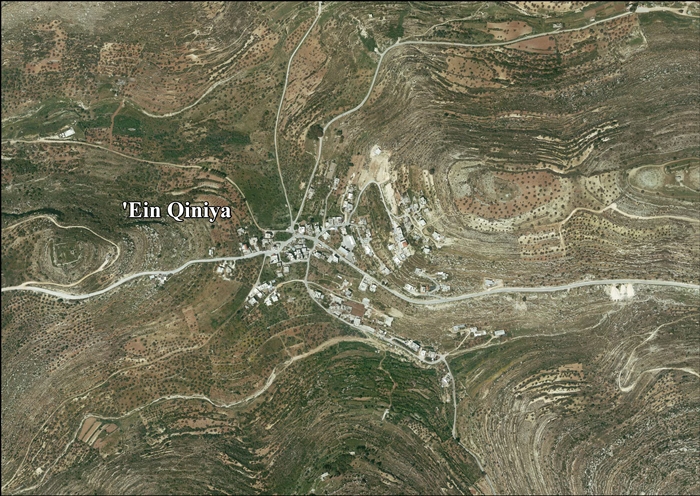
- 'Ein Qiniya aerial photo

| Cities |   | |
|---|---|---|
| Municipalities |
| |
| Village councils |
| |
| Refugee camps | ||